My Genealogy Hound
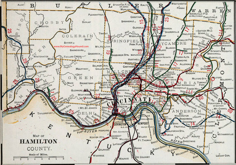
Hamilton County, Ohio 1901 Map

Locations shown include: Addyston * Allendale * Arden * Arlington Heights * Asbury * Avondale * Barnesburg * Batavia Jct. * Belmont Ave. * Bevis * Blue Ash * Bond Hill * Brachmans * Brecon * Bridgetown * Brighton * Broadwell * California * California Station * Camp Dennison * Carthage * Carthage Station * Cedar Point * Cherry Grove * Cheviot * Cincinnati * Clenery * Cleves * Cluff * College Hill * College Hill Jct. * Congress Ave. * Crescent * Crestvue * Culloms * Cumminsville * Delhi * Delta Ave. * Dent * Dunlap * East Madisonville * Echo * Eckerts * Edgemont * Eden Park * Eightmile * Elizabethtown * Elmwood * Elmwood Place * Epworth Heights * Euclid * Evendale * Fairmount * Fernbank * Forestville * Fruit Hill * Gest Station * Glendale * Glenmore * Granthorp * Gravel Pit * Griffith * Groesbeck * Groesbeck Station * Harrison * Hartwell * Hazelwood * Home City * Idlewild * Indian Hill * Ivorydale * Ivorydale Station * Kennedy * La Feuille * Lester * Linwood * Lockland * Longview * Lyndchester * Mack * Madeira * Madisonville * Madisonville Station * Maplewood * McCulloughs * Miami * Miami Grove * Milford Station * Montgomery * Mornington * Mt. Airy * Mt. Airy Station * Mt. Carmel Station * Mt. Healthy * Mt. St. Joseph * Mt. Washington * Newtown * North Bend * North Side * Norwood Heights * Norwood Park * Oakley * Oakley Grove * Park Place * Pendleton * Plainville * Pleasant Ridge * Pleasant Run * Preston * Reading * Red Bank * Remington * Rendcomb Junction * Rennselaer * Riverside * Rossmoyne * Russells * St. Barnard * St. Francis * St. Peterstown * Sand Bank * Sanitarium * Sater * Sedamsville * Sekitan * Sharon * Sharonville * Silverton * Simonsons * Sixteen Mile Stand * Snyder * South Side * Springdale * Stites * Stock Yards * Storrs * Sweetwine * Symmes * Taylors Creek * Tell Cottage * Terra Alta * Terrace Park * Tower Hill * Transit * Undercliff * Valley Junction * Wades * West Loveland * Westwood * Whitewater * White Water Park * Winslow Park * Winon Jct. * Winton Place * Winton Place Station * Woodford * Woodlawn * Wyoming *
Also shown the Hamilton County, Ohio townships of: Anderson * Colerain * Columbia * Crosby * Delhi * Green * Harrison * Millcreek * Springfield * Sycamore * Symmes * White Water *
This Hamilton County map is a portion of an 1901 Ohio map by Cram.
View additional Ohio Maps here: Ohio County Maps
County maps from other states can be viewed here: State County Maps
Additional Hamilton County resources: Hamilton County, Ohio History and Genealogy
Use the links at the top right of this page to search or browse thousands of family biographies.