My Genealogy Hound
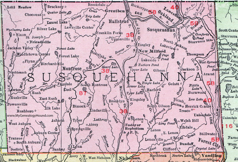
Susquehanna County, Pennsylvania 1911 Map

Locations shown include: Ainley * Alford * Ararat * Auburn * Auburn Center * Birchardville * Brackney * Brandt * Brookdale * Broolyn * Burnwood * Choconut * Clifford * Cool * Dimock * Doolittle * Dundaff * East Lenox * East Rush * Elkdale * Elk Lake * Fairdale * Flynn * Forest City * Forest Lake * Foster * Franklin Forks * Friendsville * Gelatt * Gibson * Greatbend (Great Bend) * Hallstead * Harford * Heartlake (Heart Lake) * Herrick Center * Hickorygrove (Hickory Grove) * Hopbottom P O (Hop Bottom) * Jackson * Jackson Valley * Jefferson Junction * Kingsley * Lakeside * Lakeview * Lanesboro * Lathrop * Laurel Lake * Lawsville Center * Lawton * Lenox * Lenoxville * Lindaville * Little Meadow * Lynn * Middletown Center * Montrose * New Milford * Nixon * Northbranch * North Jackson * Oakland * Parma * Powersville * Royal * Rush * Rushboro * Rushville * Saint Joseph * Sankey * Silver Lake * South Auburn * South Gibson * South Montrose * Springville * Starrucca Station * Stevens Point * Stillwater * Susquehanna * Thompson * Tiffany * Tingley * Tirzah * Transue * Tresco * Tyler * Uniondale * Upsonville * Welsh Hill * West Auburn * West Lenox *
This Susquehanna County map is a portion of an 1911 Pennsylvania map by Rand McNally.
View additional Pennsylvania Maps here: Pennsylvania County Maps
County maps from other states can be viewed here: State County Maps
Use the links at the top right of this page to search or browse thousands of family biographies.