My Genealogy Hound
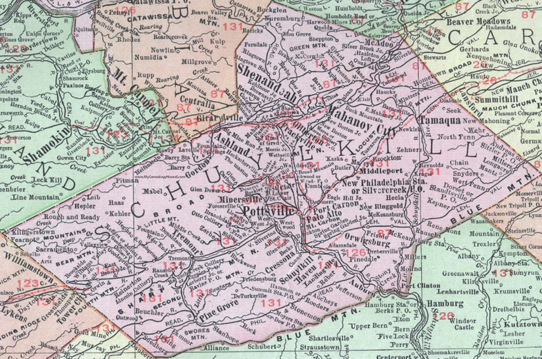
Schuylkill County, Pennsylvania 1911 Map

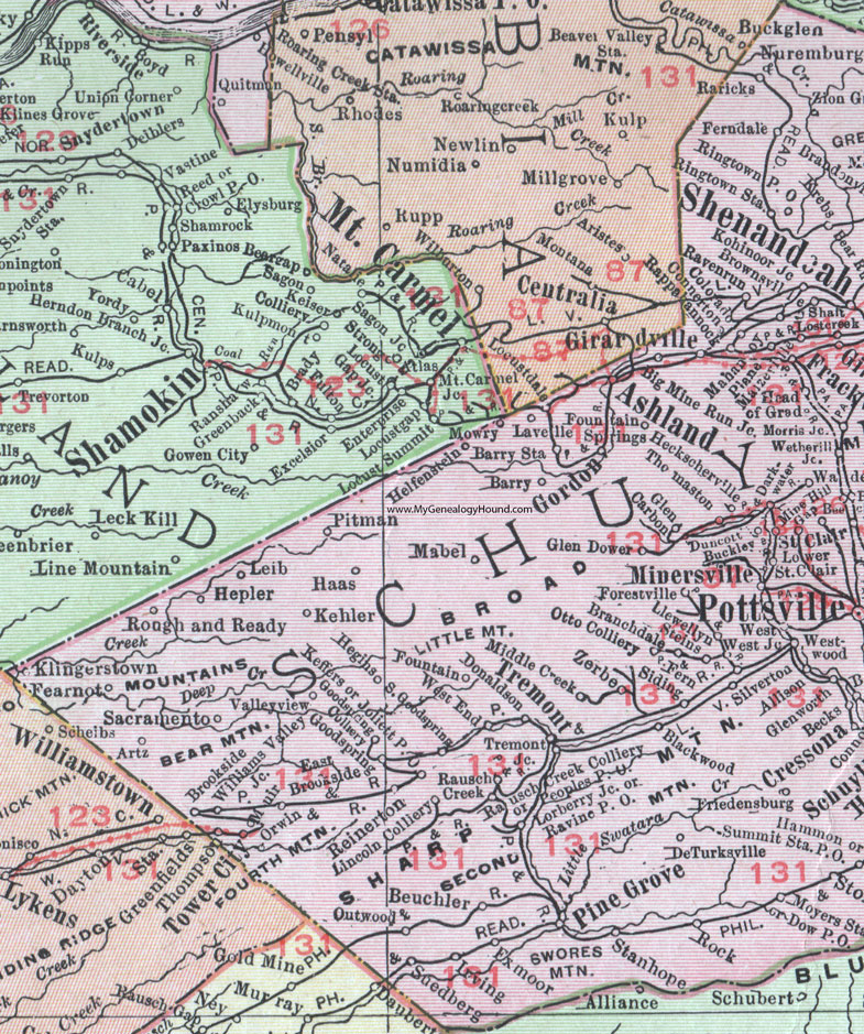
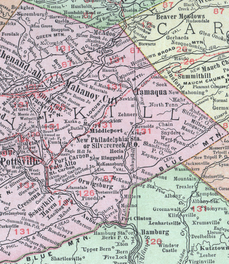
Locations shown include: Adamsdale * Allison * Andreas * Artz * Ashland *Auburn * Aucheys * Barnesville * Barry * Barry Junction * Barry Station * Bear Run Junction * Becks * Beckton * Beechwood * Beuchler * Big Mine Run Junction * Blackwood * Branchdale (Branch Dale) * Brandonville * Broad Mountain * Brockton * Brookside * Brownsville * Buckglen (Buck Glen) * Buckley * Buck Mountain * Butler * Chain * Coaldale * Colliery * Colorado * Connerton * Connor * Cressona * Cumbola * Darkwater (Dark Water) * Delano * DeTurksville * Donaldson * Dormers * Dorset * Dow P O * Drehersville * Duncott * Eagle Hill Junction * East Brookside * East Mahoney Junction * Elixer * Exmoor * Fearnot * Ferndale * Fern Siding * Forestville * Fountain * Fountain Springs * Frackville * Friedensburg * Frisbie * Gilberton * Girard Manor * Girardville * Glen Carbon * Glen Dower * Glenworth * Goodspring * Gordon * Haas * Hammon * Haucks * Hazelton Junction * Head of Grad * Heckscherville * Hecla * Hegins * Helfenstein * Hepler * Hometown * Irving * Jefferson * Joliett P O * Kaska * Keffers * Kehler * Kelayres * Kepner * Klingerstown * Kohinoor Junction * Krebs * Kruger * Landingville * Lavelle * Leib * Lincoln Colliery * Llewellyn * Lobster Creek * Lofty * Longacre * Lorberry Junction * Lower Saint Clair * Mabel * Mahanoy City * Mahanoy Plane * Maizeville * Mantz * Maryd * McAdoo * McCormick * McKeansburg * McKeansburg Station * Middle Creek * Middleport * Millers * Mine Hill Gap * Minersville * Mintzers * Molino * Morea * Morea Colliery P O * Morris Junction * Mount Carbon * Mowry * Moyers Station * New Boston * New Boston Junction * Newkirk * New Philadelphia Station * New Ringgold * North Penn * Nuremburg * Oneida * Orwigsburg * Orwin * Otto Colliery * Outwood * Palo Alto * Parkplace (Park Place) * Peoples P O * Pinedale * Pine Grove * Pitman * Port Carbon * Port Clinton * Pottsville * Quakake * Rappahannock * Raricks * Rausch Creek * Rausch Creek Colliery * Rauschs * Ravenrun (Raven Run) * Ravine P O * Reber * Reinerton * Rene Mont * Reynolds * Ringtown * Ringtown Station * Rock * Roeders * Rough and Ready * Sacramento * Saint Clair * Saint Nicholas * Schuylkill Haven * Seek * Shaft * Shenandoah * Sheppton * Silver Brook * Silver Brook Junction * Silvercreek P O (Silver Creek P O) * Silverton * Sittler P O * Snyders * South Goodspring * Spring Garden * Spring Garden Junction * Stanhope * Staudtsville P O * Steins * Stonemont * Stony Creek * Suedberg * Summit Station P O * Tamanend * Tamaqua * Thomaston * Thompson * Tower City * Tremont * Tremont Junction * Trenton * Tuscarora * Valleyview (Valley View) * Vulcan * Wadesville * Wad P O * Wehr * West * West End * West Junction * Westwood * Wetherill Junction * Williams Valley * Zehners * Zerbe * Zion Grove *
This Schuylkill County map is a portion of an 1911 Pennsylvania map by Rand McNally. See the enlarged map views below.

An enlarged view of western Schuylkill County, Pennsylvania on an 1911 map by Rand McNally.

An enlarged view of eastern Schuylkill County, Pennsylvania on an 1911 map by Rand McNally.
View additional Pennsylvania Maps here: Pennsylvania County Maps
County maps from other states can be viewed here: State County Maps
Use the links at the top right of this page to search or browse thousands of family biographies.