My Genealogy Hound
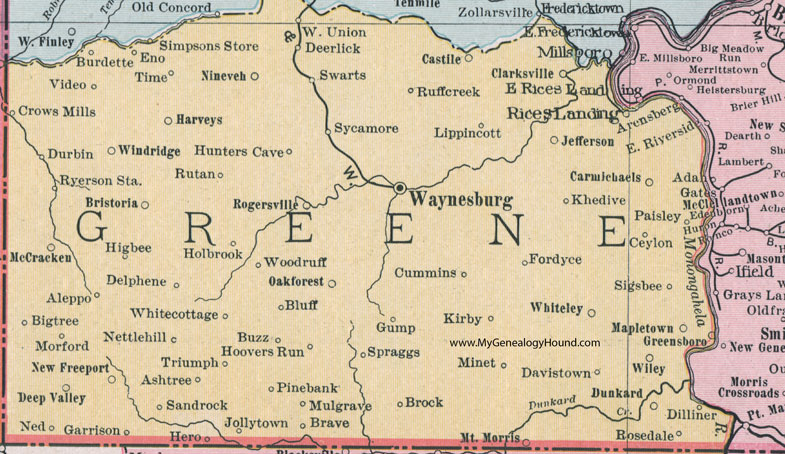
Greene County, Pennsylvania 1911 Map

Locations shown include: Aleppo * Ashtree * Bigtree (Big Tree) * Bluff * Brave * Bristoria * Brock * Burdette * Buzz * Carmichaels * Castile * Ceylon * Clarksville * Crows Mill * Cummins * Davistown * Deep Valley * Deerlick * Delphene * Dilliner * Dunkard * Durbin * Eno * Fordyce * Garrison * Greensboro * Gump * Harveys * Hero * Higbee * Holbrook * Hoovers Run * Hunters Cave * Jefferson * Jollytown * Khedive * Kirby * Lippincott * Mapletown * McCracken * Minet * Morford * Mount Morris * Mulgrave * Ned * Nettlehill (Nettle Hill) * New Freeport * Ninevah * Oakforest (Oak Forest) * Paisley * Pinebank (Pine Bank) * Rices Landing * Rogersville * Rosedale * Ruffcreek (Ruff Creek) * Rutan * Ryerson Station * Sandrock * Sigsbee * Simpsons Store * Spraggs * Swarts * Sycamore * Time * Triumph * Video * Waynesburg * West Union * Whitecottage (White Cottage) * Whitely * Wiley * Windridge (Wind Ridge) * Woodruff *
This Greene County map is a portion of an 1911 Pennsylvania map by Rand McNally.
View additional Pennsylvania Maps here: Pennsylvania County Maps
County maps from other states can be viewed here: State County Maps
Use the links at the top right of this page to search or browse thousands of family biographies.