My Genealogy Hound
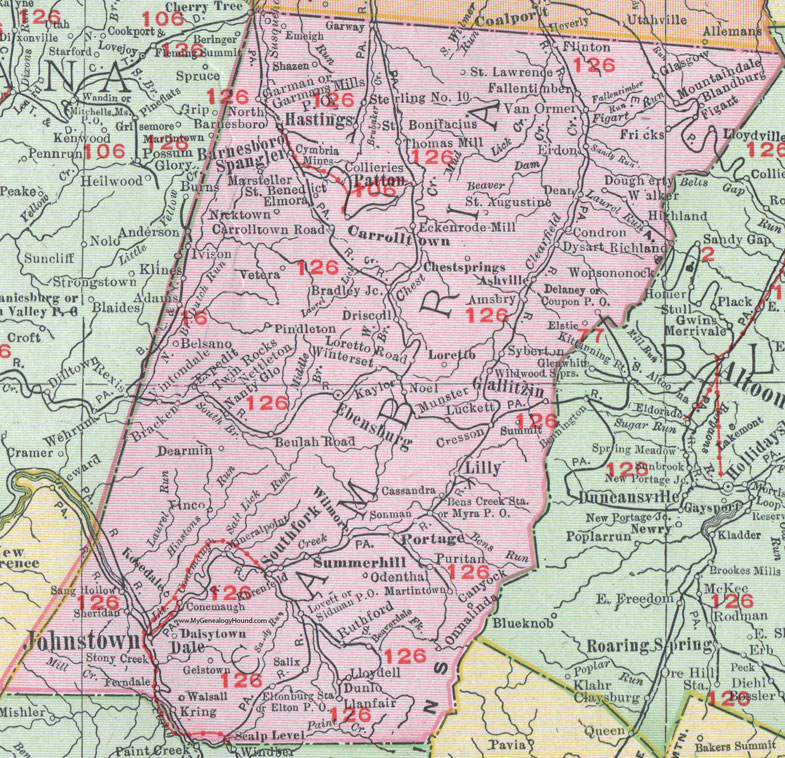
Cambria County, Pennsylvania 1911 Map

Locations shown include: Adams * Amsbry * Ashville * Barnesboro * Beaverdale * Belsano * Bens Creek Station * Beulah Road * Blandburg * Bracken * Bradley Junction * Canyock * Carrolltown * Carrolltown Road * Cassandra * Chestsprings (Chest Springs) * Collieries * Condron * Conemaugh * Coupon P O * Cresson * Cymbria Mines * Daisytown * Dale * Dean * Dearmin * Delaney * Dougherty * Driscoll * Dunlo * Dysart * Ebensburg * Eckenrode Mill * Ehrenfield * Elmora * Elstie * Eltonburg P O * Eltonburg Station * Emeigh * Erdon * Expedit * Fallentimber * Ferndale * Figart * Flinton * Fricks * Gallitzin * Garman * Garmans Mills P O * Garway * Geistown * Glasgow * Hastings * Highland * Ivison * Johnstown * Kaylor * Kring * Lilly * Llanfair * Lloydell * Loretto * Loretto Road * Lovett * Luckett * Marsteller * Martintown * Mineralpoint (Mineral Point) * Mountaindale * Munster * Myra P O * Nanty Glo * Nettleton * Nicktown * Noel * North Barnesboro * Odenthal * Onnalinda * Patton * Pindleton * Portage * Puritan * Richland * Rosedale * Ruthford * Saint Augustine * Saint Benedict * Saint Bonifacius * Saint Lawrence * Salix * Sang Hollow * Saxman * Scalp Level * Shazen * Sheridan * Sidman P O * Sonman * Southfork (South Fork) * Spangler * Sterling No. 10 * Stony Creek * Summerhill * Summit * Syberton * Thomas Mill * Twin Rocks * Van Ormer * Vetera * Vinco * Vintondale * Walker * Walsall * Wildwood Springs * Wilmore * Winterset *
This Cambria County map is a portion of an 1911 Pennsylvania map by Rand McNally.
View additional Pennsylvania Maps here: Pennsylvania County Maps
County maps from other states can be viewed here: State County Maps
Use the links at the top right of this page to search or browse thousands of family biographies.