My Genealogy Hound
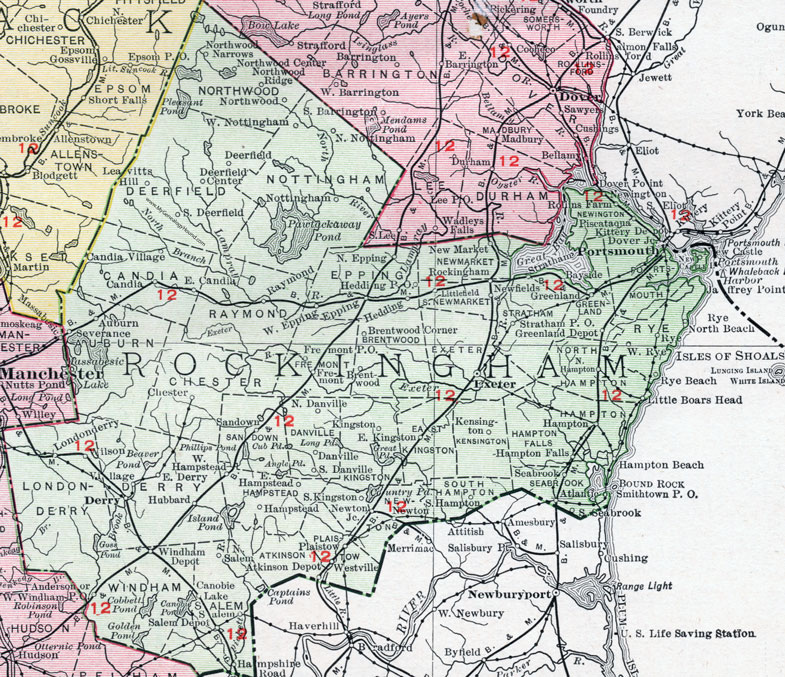
Rockingham County, New Hampshire Map, 1912

Locations shown include: Anderson, Atkinson Depot, Atlantic, Auburn, Bayside, Brentwood, Brentwood Corner, Candia, Candia Village, Canobie Lake, Chester, Danville, Deerfield, Deerfield Center, Derry, East Candia, East Derry, East Hampstead, East Kingston, Epping, Exeter, Fremont, Greenland, Greenland Depot, Hampshire Road, Hampstead, Hampton, Hampton Beach, Hampton Falls, Hedding, Hubbard, Kensington, Kingston, Leavitts Hill, Little Boars Head, Littlefield, Londonderry, New Castle, Newfields, Newington, New Market, Newton, Newton Junction, North Danville, North Epping, North Hampton, North Nottingham, Northwood, Northwood Center, Northwood Narrows, Northwood Ridge, Nottingham, Piscataqua, Plaistow, Portsmouth, Raymond, Rockingham, Rye, Rye Beach, Rye North Beach, Salem, Salem Depot, Sandown, Seabrook, Severance, Smithtown, South Danville, South Deerfield, South Hampton, South Kingston, South Seabrook, Stratham, Village, West Epping, West Hampstead, West Nottingham, West Rye, Westville, West Windham, Wilson, Windham Depot.
This Rockingham County map is a portion of a 1912 New Hampshire map by Rand McNally.
View additional New Hampshire maps here: New Hampshire County Maps
County maps from other states can be viewed here: State County Maps
Use the links at the top right of this page to search or browse thousands of family biographies.