My Genealogy Hound
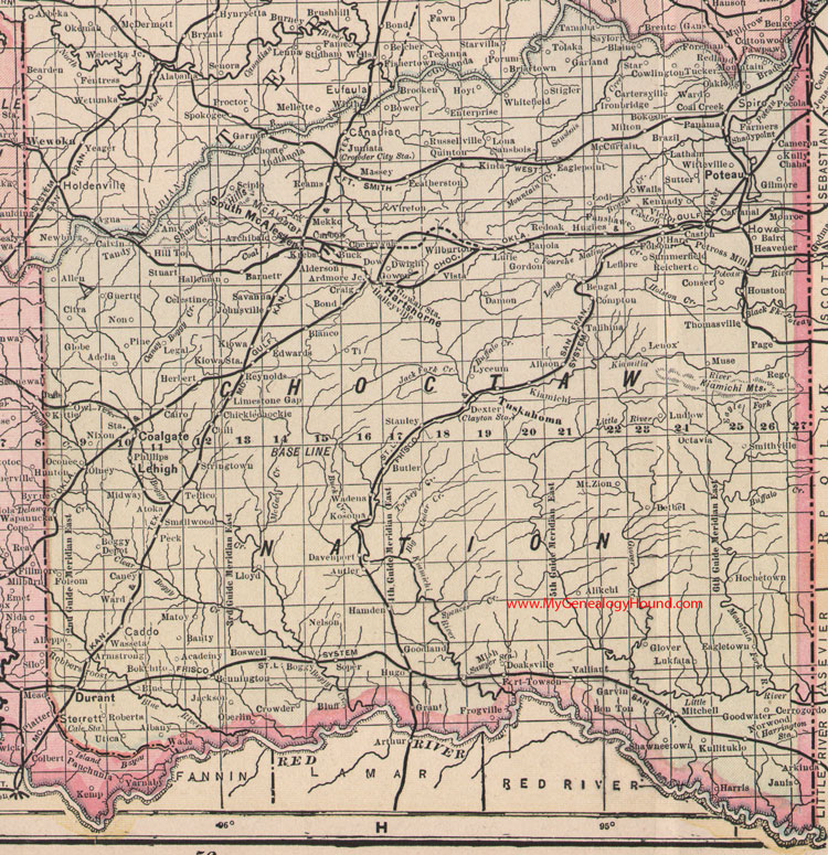
Choctaw Nation Indian Territory 1905 Map

Locations shown include: Academy, Adelia, Albany, Albion, Alderson, Alikchi, Allen, Alleppo, Amy, Antler, Archibald, Ardmore Junction, Armstrong, Atoka, Baird, Banty, Barnett, Bengal, Bennington, Bethel, Blaine, Blanco, Blue, Boggy, Boggy Depot, Bokchito, Bokoshe, Bond, Bon Ton, Boswell, Bower, Bradeau, Brazil, Brooken, Buck, Butler, Byrne, Caddo, Cairo, Cale Station, Calvin, Cameron, Canadian, Caney, Carbon, Cartersville, Caston, Cavanal, Celestine, Cerro Gordo, Cherryvale, Chickiechockie, Chili, Choate, Citra, Clayton Station, Coal Creek, Coalgate, Compton, Conser, Cowlington, Craig, Crowder, Crowder City Station, Damon, Davenport, Dexter, Doaksville, Dow, Durant, Dwight, Eagle Point, Eagletown, Edwards, Enterprise, Fanshawe, Farmers, Featherston, Folsom, Fort Dowson, Frogville, Garland, Garner, Garvin, Gilmore, Globe, Glover, Golconda, Goodland, Goodwater, Gordon, Gowan Station, Gowen, Grant, Guertie, Haileyville, Halleman, Hamden, Harrington Station, Harris, Hartshorne, Heavener, Herbert, Hill Top, Hochetown, Houston, Howe, Hoyt, Hughes, Hugo, Indianola, Iron Bridge, Jackson, Janis, Johnsville, Juniata, Kennady, Kiamichi, Kinta, Kiowa, Kiowa Station, Kittie, Kosonia, Krebs, Kullituklo, Kully Chaha, Latham, Leflore, Legal, Lehigh, Lenox, Limestone Gap, Lloyd, Lodi, Lona, Ludlow, Lukfata, Lutie, Lyceum, Massey, Matoy, McAlester, McCurtain, Mekko, Miah, Midway, Milton, Mitchell, Monroe, Mountain, Mount Zion, Muse, Nelson, Newburg, Nixon, Non, Norwood, Oakledge, Oberlin, Oconee, Octavia, O'Hara, Olney, Owl, Page, Panama, Panola, Peck, Petross Mill, Phillips, Pine, Pocola, Poteau, Quinton, Reams, Red Oak, Rego, Reichert, Reynolds, Roberta, Russellville, Sansbois, Savanna, Sawyer Station, Saylor, Scipio, Shadypoint, Shawneetown, Smallwood, Smithville, Soper, South McAlester, Spiro, Stanley, Star, Sterrett, Stigler, Stringtown, Stuart, Summerfield, Sutter, Talihina, Tamaha, Tandy, Tellico, Thomasville, Tolaka, Tucker, Tuskahoma, Utica, Valliant, Victor, Vireton, Vista, Wade, Wadena, Walls, Wapanucka, Ward, Wasseta, Wilburton, Witteville
This is a portion of a Oklahoma and Indian Nation map by J. N. Matthews, 1903, published 1905.
Reprints of this map are available from Hearthstone Legacy: Chocataw Nation Indian Nation 1905 Map
View additional Oklahoma County and Indian Nation Maps here: Oklahoma County and Indian Nation Maps
County maps from other states can be viewed here: State County Maps
Use the links at the top right of this page to search or browse thousands of family biographies, historic maps and photographs.