My Genealogy Hound
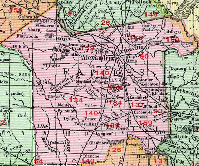
Rapides Parish, Louisiana 1911 Map

Locations shown include: Alexandria, Annadale, Arno, Ashton, Ball, Barrett, Bennettville, Bijou, Blanche, Boyce, Bruce, Buckeye, Cheneyville, Chihuahauita, Clover, Cloverdale, Condor, Cornstalk, Crane, Dyer, Echo P O, Elmer, Ems, Dillow, Dysons, Flatwoods, Flowerton, Forest Hill, Forest Hill Station, Glenmora, Halliday, Hineston P O, Holdup, Holloway, Lamothe, Lamourie, Latanier, Lecompte, Lena Station, Longleaf, Loyds, Magda, Meeker, Melder, Milford, Moorland P O, Moreland, Nelsonville, Osborn, Otis, Paul P O, Pinehurst, Pineville, Quadrate, Raw Hide, Richland, Roland, Ruby, Sartori, Sharp, Sycamore, Tioga, Togo, Tyrawley, Valderouge, Violet, Weil, Welchton, Whittington, Wilda, Woodworth, Zimmerman.
This Rapides Parish map is a portion of a 1911 Louisiana map by Rand McNally.
View additional Louisiana Maps here: Louisiana Parish Maps
County maps from other states can be viewed here: State County Maps
Use the links at the top right of this page to search or browse thousands of family biographies.