My Genealogy Hound
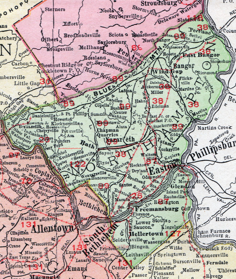
Northampton County, Pennsylvania 1911 Map

Locations shown include: Ackermanville * Aluta * Arndts * Asa * Bangor * Bath * Belfast Junction * Belfast P O * Benders Junction * Benningers * Berlinsville * Bethlehem * Bingen * Brodhead Station * Bushkill Center * Butztown * Chapman Quarries * Cherryville * Clyde * Coffeetown * Copella * Coplay * Dairy * Danielsville * Delabola * Delps * Dryland * East Bangor * Easton * Edelman * Flicksville * Florence * Freemansburg * Glendon * Hahns * Hanoverville * Harper * Hecktown * Hellertown * Hope * Horns Springs * Howerton * Howerton Junction * Howersville * Indianland * Island Park * Johnsonville * Johnsonville Station * Katellen * Keplers * Klecknersville * Kreidersville * Lafona * Leithsville * Lockport * Lower Saucon * Macada Station * Martins Creek * Martins Creek Junction * Miller * Moorestown * Morgans Hill * Mount Bethel * Nazareth * Nazareth Junction * North Bangor * Northampton * Odenwelder Station * Palmerton * Pen Argyl * Petersville * Pomfert * Pompeii * Point Phillip * Portland * Raubsville * Redington * Republic * Richmond * Roseto * Samel * Sandts Eddy * Santee * Saylorsburg Junction * Seemsville * Seidersville * Selmer? * Siegfried * Slatefield * Slateford * Slate Valley * Snyder * South Bethlehem * South Easton * Steuben * Stockerton * Stonechurch (Stone Church) * Stouts * Summit * Tatamy * Walnutport * Walters Mills * Wassergass * Weaversville * Wind Gap * Youngs * Zucksville *
This Northampton County map is a portion of an 1911 Pennsylvania map by Rand McNally.
View additional Pennsylvania Maps here: Pennsylvania County Maps
County maps from other states can be viewed here: State County Maps
Use the links at the top right of this page to search or browse thousands of family biographies.