My Genealogy Hound
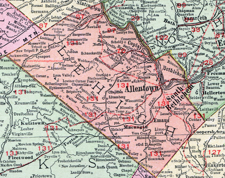
Lehigh County, Pennsylvania 1911 Map

Locations shown include: Alburtis * Allentown * Balliettsville * Best * Bethlehem * Breinigsville * Catasauqua * Cementon * Center Valley * Chapman * Claussville * Consolidated * Coopersburg * Coplay * Corning * Crane * Dillinger * Dillingersville * East Texas * Eckert * Egypt * Emaus (Emmaus) * Emaus Junction * Emerald * Emerald Station * Fogelsville * Friedensville * Fullerton * Germans Corner * Germansville * Guths Station * Haines * Hartzell * Heinley * Hoffman * Hosenack * Hynemansville * Ironton * Ironton Junction * Jacksonville * Jordan * Jordan Valley * Lanark * Laurys Station * Leather Corner Post * Lehigh Furnace * Limeport * Little Run Junction * Lochland * Laros * Litzenberg * Locust Valley * Lowhill * Lynnport * Lynnville * Lyon Valley * Lyonville * Macungie * Metamora * Mickleys * Minesite * Minnich * Mosserville * Neffs * Newhard * Newside * New Tripoli P O * Old Zionsville * Orefield * Plover * Powder Valley * Ringers * Rittersville * Risingsun (Rising Sun) * Rockdale * Saegersville * Saucona * Saylor * Schadts * Schnecksville * Scheidy * Seiberling * Seiple * Seipstown * Shimerville * Siegersville * Sigmund * Slatedale * Slatington * Spring Creek * Steinsville * Sterlersville * Stetler * Stines Corner * Switzer * Trexlertown * Tripoli * Vera Cruz * Walberts * Wallner * Wanamakers * Weidasville * Wescoville * Wiesenburg * Zionsville *
This Lehigh County map is a portion of an 1911 Pennsylvania map by Rand McNally.
View additional Pennsylvania Maps here: Pennsylvania County Maps
County maps from other states can be viewed here: State County Maps
Use the links at the top right of this page to search or browse thousands of family biographies.