My Genealogy Hound
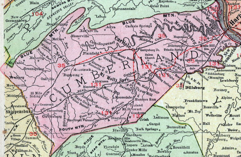
Cumberland County, Pennsylvania 1911 Map

Locations shown include: 38 Mile Siding * Accra * Allen * Alterton * Balfour * Barnitz * Bigspring (Big Spring) * Bloserville * Boiling Springs * Bonny Brook * Bowmansdale * Brandtsville * Carlisle * Carlisle Junction * Carlisle Springs * Camphill (Camp Hill) * Cleversburg * Cleversburg Junction * Craighead * Dickinson * Dillsburg Junction * Doublinggap (Doubling Gap) * Eberly * Elliottson * Enola * Entlerville * Gettysburg Junction * Goodhope (Good Hope) * Goodyear * Grantham * Greason * Greenspring (Green Spring) * Greider * Greythorne * Hampden * Hatton * Hays Grove * Heberling * Henry Clay * Hogestown * Hunters Run * Huntsdale * Kerrsville P O * Laurel * Lees Crossroads * Leidighs * Longsdorf * McCrea * Mechanicsburg * Middlesex * Middlespring (Middle Spring) * Montsera * Mooredale * Moors Mill * Mount Holly Springs * Mountrock (Mount Rock) * Mount Stewart * Mount Tabor * Newburg * New Cumberland * New Kingstown * Newville * Oakville * Ore Branch Junction * Pine Grove Furnace * Plainfield * Riverton * Rossmoyne * Salem Church * Shepherdstown * Shippensburg * Shiremanstown * Starners * Toland * Trindle Spring * Upper Mill * Walnut Bottom * Wertzville * West Fairview * White Hill * White Hill Station * Williams Grove * Williams Mill P O * Wingert * Wormleysburg *
This Cumberland County map is a portion of an 1911 Pennsylvania map by Rand McNally.
View additional Pennsylvania Maps here: Pennsylvania County Maps
County maps from other states can be viewed here: State County Maps
Use the links at the top right of this page to search or browse thousands of family biographies.