My Genealogy Hound
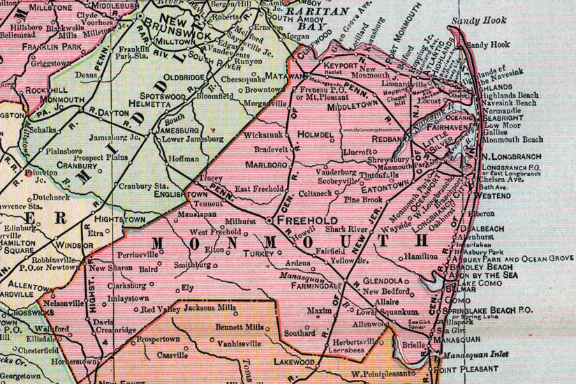
Monmouth County, New Jersey, 1905 Map

Locations shown include: Allaire, Allenhurst, Allentown, Allenwood, Ardena, Asbury Park, Atlantic Highlands, Avon by the Sea, Baird, Belford, Belmar, Bradevelt, Bradley Beach, Branchport, Brielle, Chapel Hill, Clarksburg, Cliffwood, Coltsneck (Colts Neck), Como, Creamridge (Cream Ridge), Davis, Dealbeach (Deal Beach), East Freehold, East Longbrach (East Long Branch), Eatontown, Elberon, Ellisdale, Elton, Ely, Englishtown, Fairhaven, Fairfield, Farmingdale, Freehold, Freneau P O, Galilee, Glendola, Green Grove Avenue, Hamilton, Hazlet, Highlands, Highlands Beach, Highlands of the Navesink, Hiltons, Holmdel, Hopping, Hopping Junction, Hornerstown, Howell, Imlaystown, Interlaken, Keansburg, Keyport, Lake Como, Larrabees, Leonardville, Lincroft, Little Silver, Locust, Longbranch City (Long Branch City), Longbranch P O (Long Branch P O), Lorillard, Lower Squankum, Low Moor, Manalapan, Manasquan, Marlboro, Matawan, Maxim, Middletown, Milhurst, Mohingson Junction, Monmouth Beach, Monmouth Park, Monmouth Park Junction, Morganville, Mount Pleasant, Navesink, Navesink Ave., Navesink Beach, Nelsonville, New Bedford, New Monmouth, New Sharon, Newtown, Normandie, North Asbury Park, North Longbranch (North Long Branch), Oakhurst, Ocean Grove, Oceanic, Oceanport, Perrineville, Pine Brook, Point Pleasant, Port Monmouth, Redbank (Red Bank), Red Valley, Robbinsville P O, Sandy Hook, Scobeyville, Seabright, Sea Girt, Shady Side, Shark River, Shrewsbury, Smithburg, Southard, Spring Lake, Spring Lake Beach P O, Stone Church, Tennent, Tintonfalls (Tinton Falls), Tracey, Turkey, Vanderburg, Villarpark (Villa Park), Walnford, Waterwitch, Wayside, Westend (West End), West Freehold, West Longbranch (West Long Branch), Wickatunk, Yellow Br.
This Monmouth County map is a portion of a 1905 New Jersey map by George F. Cram.
View additional New Jersey Maps here: New Jersey County Maps
County maps from other states can be viewed here: State County Maps
Use the links at the top right of this page to search or browse thousands of family biographies.