My Genealogy Hound
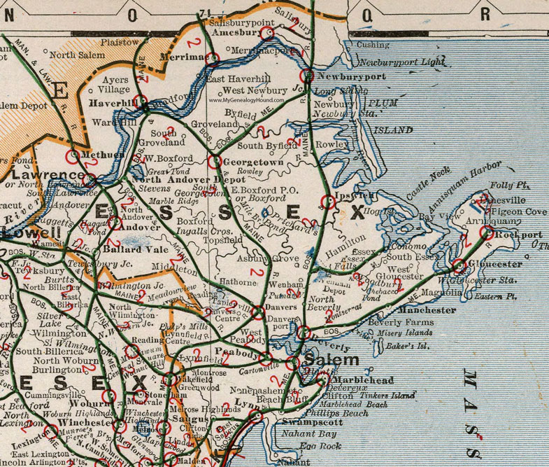
Essex County, Massachusetts 1901 Map

Locations shown include: Amesbury * Andover * Annisquam * Asbury Grove * Ayers Village * Ballard Vale (Ballardvale) * Bay View * Beach Bluff * Beverly * Beverly Farms * Boxford * Bradford * Byfield * Clifton * Cliftondale * Cushing * Danvers *Danvers Centre * Danversport * Devereux * East Boxford P O * East Haverhill * East Saugus * Essex * Essex Falls * Georgetown * Gloucester * Groveland * Haggetts * Hamilton * Hathorne * Haverhill * Ingalls Crossing * Ipswich * Lanesville * Lawrence * Lowell Junction * Lynn * Lynnfield * Lynnfield Centre * Magnolia * Manchester * Marblehead * Marble Ridge * Merrimac * Merrimacport * Methuen * Middleton * Nahant * Nanepashemet * Newbury * Newburyport * Newbury Station * North Andover * North Andover Depot * North Beverly * North Lawrence * Peabody * Phelp's Mills * Phillips Beach * Pigeon Cove * Putmanville * Reading * Rockport * Rowley * Salem * Salisbury * Salisburypoint (Salisbury Point) * Saugus * South Essex * South Georgetown * South Groveland * South Lawrence * Stevens * Swampscott * Tapleyville * Topsfield * Ward Hill * Wenham * Wenham Depot * West Boxford * West Gloucester * West Gloucester Station * West Newbury * West Peabody * Woodbury *
This Essex County map is a portion of a 1901 Massachusetts map by Cram.
View additional Massachusetts Maps here: Massachusetts County Maps
County maps from other states can be viewed here: State County Maps
Use the links at the top right of this page to search or browse thousands of family biographies.