My Genealogy Hound
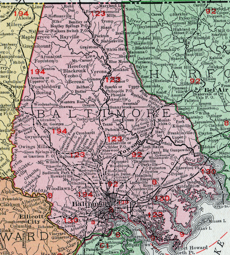
Baltimore County, Maryland 1911 Map

Locations shown include: Arbutus * Arcadia * Arlington * Armacost * Back River * Baldwin * Baltimore * Baynesville * Bay View * Belfast * Bengies * Bentley * Bentley Springs P O * Berean * Big Gunpowder * Blackrock * Blue Mount * Boring * Bradshaw * Brightside * Brooklandville * Butler * Carny * Carroll * Catonsville * Chase * Chattolanee * Clifford * Cockeysville * Colgate * Colgate Creek * Corbett * Cowenton * Cronhardt * Cylburn * Dar * Delight * Dundalk * Eccleston * Elko * Emory Grove * Eudowood * Evergreen * Falls * Foreston * Fork * Fowblesburg * Franklinville * Freeland * Fullerton * Gardenville * Garrison Forest * Garrison P O * Gittings P O * Glenarm * Glencoe * Glen Morris * Glyndon * Gorsuchs Mills * Govans * Grange * Graystone * Green Springs Junction * Gwynnbrook * Halethorpe * Hamilton * Harewood Park * Hartley * Hereford * Herring Run * Hoffmanville * Hollinsland * Homeland * Howardville * Hyde * Jacksonville * Jessop * Kenwood * Kingsville * Lake * Landsdowne * Lauraville * Loch Raven * Long Green * Long Green P O * Loreley * Loudon Park * Lutherville * Lystra * Manor * Maryland Line * McDonogh * Melvale * Middle River * Monkton * Mount Carmel * Mount Hope * Mountvista * Mount Washington * Mount Wilson * Mount Winans * North Point * Notch Cliff * Notre Dame * Oakleigh * Orange Grove * Orangeville * Oregon * Overlea * Owings Mills * Padonia * Parkton * Parkville * Philopolis P O * Phoenix * Pikesville P O * Poplar * Raspeburg * Rayville * Reckord (Reckford) * Reisterstown * Relay * Rider P O * Rockland * Rogers * Roland * Rosedale * Roslyn * Rossville * Ruhl * Rutledges Siding * Ruxton * Saint Georges * Saint Helena * Shane * Shawan * Sheppard * Sherwood * Sollers * Sparks * Sparrows Point * Stablersville * Stemmers Run * Stevenson * Sudbrook Park * Summerfield * Sunnybrook * Sweetair (Sweet Air) * Texas * Timonium * Towson * Trenton * Trump * Turner * Upperco P O * Upper Falls * Verona * Walbrook * Walker * Walkers Switch Junction * Walters * Warren * Western Run * Westport * White Hall * Whitemarsh P O * Woodberry * Woodbrook * Woodensburg * Woodlawn * Yeoho *
This Baltimore County map is a portion of a 1911 Maryland map by Rand McNally.
View additional Maryland Maps here: Maryland County Maps
County maps from other states can be viewed here: State County Maps
Use the links at the top right of this page to search or browse thousands of family biographies.