My Genealogy Hound
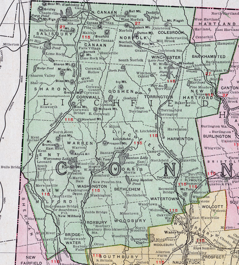
Litchfield County, Connecticut, 1911 Map

Locations shown include: Bakersville, Bantam, Barkhampsted, Barkhamsted Station, Bethlehem, Boardman P O, Boardmans Bridge, Bridgewater, Bulls Bridge, Burville, Campville, Canaan, Chapinville, Chapinville Station, Colebrook, Colebrook Station, Cornwall, Cornwall Bridge, Cornwall Center, Cornwall Hollow, East Canaan, East Cornwall, East Kent, East Litchfield, East Windsted, Ellsworth, Falls Village, Fluteville, Gaylordsville, Goshen, Grants, Greystone, Hampsted, Harwinton, Hotchkissville, Huntsville, Judds Bridge, Kent, Kent Furnace, Lake, Lakeville, Lanesville, Leonard, Lime Rock, Lime Rock Station, Litchfield, Maltbys, Merwinsville, Mill Brook, Milton, Minortown, Morris, Nepaug, New Hartford, New Milford, New Preston, New Preston Station, Norfolk, Norfolk Summit, Northfield, North Kent, Northville, North Woodbury, Oakville, Ore Hill, Orton, Pine Grove, Pine Meadow, Pleasant Valley, Plymouth, Reynolds Bridge, Riverton, Robertsville, Romford, Roxbury, Roxbury Falls, Roxbury Station, Salisbury, Sharon, Sharon Valley, South Canaan, South Kent, South Norfolk, State Line, Still River, Summit, Terryville, Thomaston, Torringford, Torrington, Twin Lakes, Warren, Washington, Washington Depot, Watertown, Weltons, West Cornwall, West Goshen, West Morris P O, West Norfolk, West Torrington, West Winsted, Whiting River, Winchester Center, Winsted, Woodbury, Woodville.
This Litchfield County map is a portion of a 1911 Connecticut map by Rand McNally.
View additional Connecticut Maps here: Connecticut County Maps
County maps from other states can be viewed here: State County Maps
Use the links at the top right of this page to search or browse thousands of family biographies.